When the weather is good, there is so much to do outdoors in Ireland – solo, or with family or friends. Here are seven activities - with locations, descriptions, tips and some maps for a general guide.
Below you can read John O'Dwyer's pick for a great walking path, Conor O'Keeffe on a running route, Rozanna Purcell recommends a hiking trail, Mary McCarthy on an outdoor swimming location, Ian O'Riordan picks a cycle trip, Sylvia Thompson on a family-friendly park and Fiona Alston selects a popular outdoor gym.
And remember, whatever you do and wherever you go, please be safe. And enjoy.
Name Barrow Way
Distance 15km linear trail
Approximate duration 3 hours
Difficulty Easy
Starting point Google Maps Barrow Bridge, Ballytiglea (grid reference S 709 504)
Finish St Mullin's
Amenities Graiguenamanagh and St Mullin's
Memorable outing following the serene towpath of the River Barrow by historic Graiguenamanagh to St Mullin's with good underfoot conditions throughout.

Name: The Barrow Way: Carlow-Bagenalstown
Length: 18km
Grade: Easy
Terrain: Road, track and River Towpath
Route type: Loop
Footwear: Road or Trail Runners
Dogs: Dogs are permitted, dogs must be kept on a lead.
Type of trail: National Way Marked Trail – yellow arrow on black background.
Route Information: From Carlow the Barrow Way switches to the right or west bank of the River Barrow at Wellington or Graiguecullen Bridge. The 13th century Carlow Castle which protected the river crossing and around which Carlow town developed, is well worth a visit. The landscape changes south of Carlow town, flat plains are replaced by hills on either side with wooded valleys. The Castlecomer Plateau rises up on the west side. Below Carlow, the ruins of Clogrennan Castle and Clogrennan House, seat of the Rochforts can be seen on the right or west bank. Milford is a pleasant spot on the River Barrow and is particularly rich in plant and bird life – spot the herons, kingfishers and swallows among the many species of birds. The ruins of Milford Mill (1790-1965), established by the Alexander family are nearby and were once the site of a busy flour, malting and tannery business. In the 1890s the present day mill was used as a generating station for electricity with Carlow the first inland town in Ireland and the UK to have electric street lighting. Leighlinbridge is another old town built on a crossing point which was guarded by the Black Castle. The bridge at Leighlinbridge, built in 1320, is the oldest on the River Barrow. The Way now switches to the left bank and as you leave the village behind, the ancient site of Dinn Righ lies up on your right, said to be a fort of one of the former Kings of Leinster. Bagenalstown is reached shortly after passing the outdoor swimming pool. In modern times the village has won numerous awards in the Tidy Towns competition. (Aided by: Carlow Tourism)


Hike name Mount Leinster
Distance 8km
Elevation gain 612m
Approximate duration 1.5-2 hours
Difficulty Moderate
Route type Out and back
Starting point See AllTrails Mount Leinster
Amenities Limited parking
Dog friendly No
Tips Head off peak during the week or very early on weekends as it can get very busy.
Name: Clashganny Lock /River Barrow
Location: Google Map: Clashganny lock. Halfway between Borris and Graignamanagh on the low road
Brief description: Calm swimming spot with beautiful grassy banks
Amenities: Parking and toilets
Lifeguard: Summer
Water quality: Poor/moderate 2013-2018 EPA report
Tips: Swim across to the weir and lie on it letting the water bubble over you like in a jacuzzi. In warm weather it heats up. In August, pick the hanging down blackberries as you float past
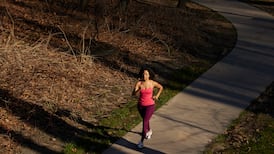
Name: The Barrow Way
Start location: Carlow
Route: Who better than former Carlow football manager Turlough O'Brien to introduce me to this route, which dips in and out of the wonderfully scenic and off-road Barrow Way, taking in Bagenalstown as far as St Mullins, and returning via Borris and Fenagh.
Distance: 103km
Time: 4.5-5.5 hours
Highlights: The Barrow Way, taking in large parts of the second longest river in Ireland, is a proper hidden gem.
Look out for: The Borris Viaduct, within striking view on the descent into the town.
Tips: Break up into shorter sections to allow time for a riverside picnic.

Park name: Oak Park Forest Park, Carlow Town
Amenities: This 120 acre park has colour coded circular walkways of varying lengths with wheelchair-accessible surfaces. Accessible playground with a slide, swings and a wheelchair swing.
Special features: A great selection of trees including beech, oak, Scots pine, larch and sycamore.
Access: Free car parking on site. Google Map "Oak Park Forest Park".
Dogs: Yes
Tip: Check out the ducks and swans on the lakes and go bird-watching for wild birds.
Name: Oak Park Forest Park, Carlow Town
Equipment: Lat pull-down, dip bars, leg press, cross trainer, rower, shoulder extension, waist extension, walker.
Location: Google Maps
Information: This recreational park has looped walking trails, a lake, playground, and toilets, and it's open from dawn until dusk.

Get Active Series
- 32 great walking routes in Ireland - one in each county
- 32 great hikes in Ireland
- 32 great running routes
- 32 great outdoor swim locations
- 32 great cycling routes
- 32 great parks
- 32 great outdoor gyms